

The Cavan Way Trail
Distance: 26km
Terrain: Varies between public road, forest track, open ground and established trails
Grade: Strenuous
The Cavan Way is a long distance linear walking route and should not be undertaken without adequate preparation.
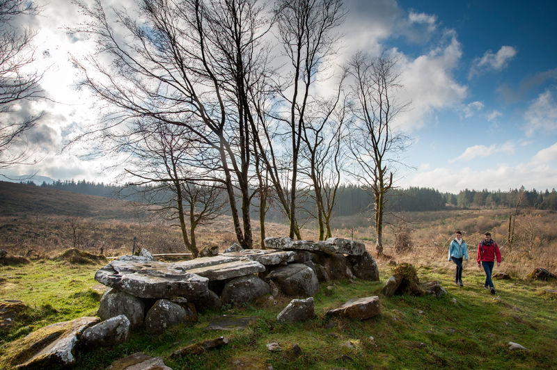
Highest Point: Giant’s Grave in Burren Forest at 260m Located in the heart of the MarbleArch Caves Global Geopark,the linear CavanWay is a pleasant hill and valley walk between Dowra, a small village near the source of the River Shannon and Blacklion inWest Cavan. The first section of the Cavan Way generally follows the course of the young Shannon River to its source at the mystical Shannon Pot,regarded as the surface source of the longest river in Ireland.The walk travels along quiet country roads, across valley landscapes and riverside paths to the
more enclosed uplands of the spring line of the river’s source at the Shannon Pot. The CavanWay then ascends from the Shannon Pot into the upland limestone landscapes on the northern flanks of Cuilcagh Mountain. This includes the magnificent Burren Forest, one of the finest prehistoric landscapes in Ireland. Once through the Burren Forest, the Cavan Way descends into the village of Blacklion through the almost lunar limestone landscapes of Corratirrim, taking in breathtaking views of Lough MacNean to the north and Cuilcagh Mountain to the south along the way
Facilities:
Information panels are located at various places along the Cavan Way
Picnic tables are available at Dowra, Blacklion, Shannon Pot and Burren Forest
