


Belturbet Walking Trails
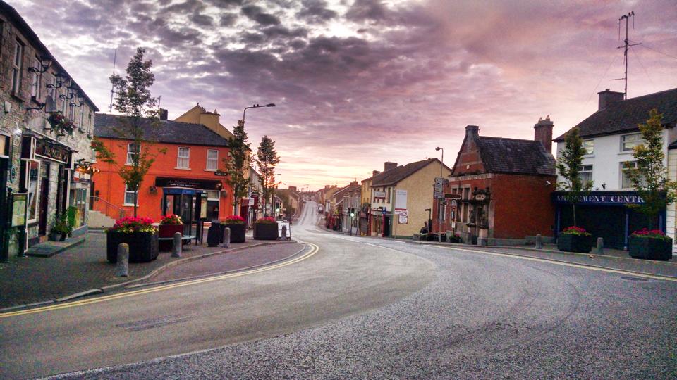
Belturbet takes its name from ‘Tairbert Island’ and means ‘The Mouth of Tairbert’. Belturbet is a lively town and an excellent base for exploring the river and the Shannon-Erne Canal. Strategically placed at the head of the River Erne, the O’Reilly clan were dominant here and historically, the territory was known as East Breffni. Steeped in history, there are many interesting things to see along the heritage trail in Belturbet. The trail begins in the centre of the town, known locally as the Diamond, across from the historic Town Hall.The trail takes you along the town with maps, information panels and plaques giving you further information on key sites
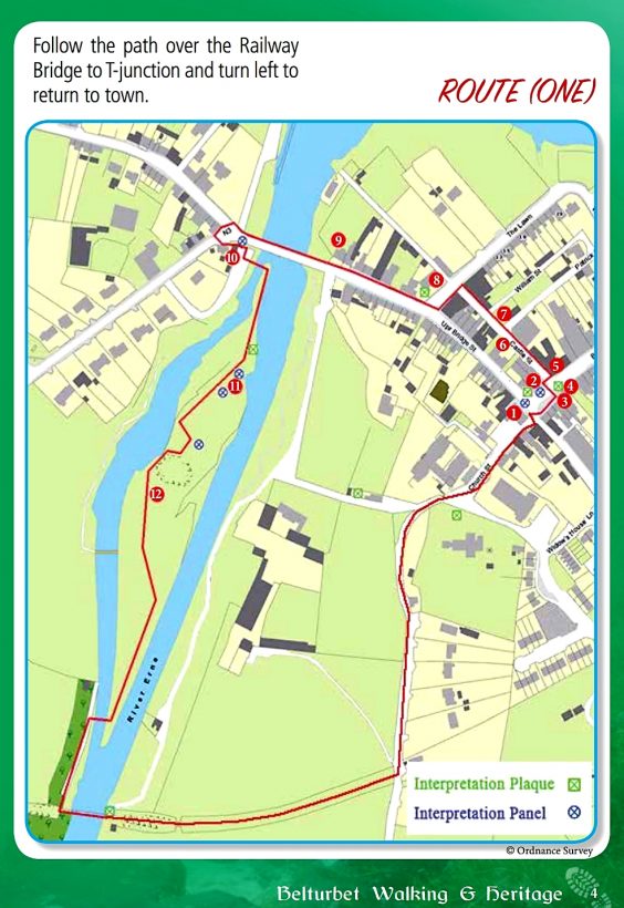
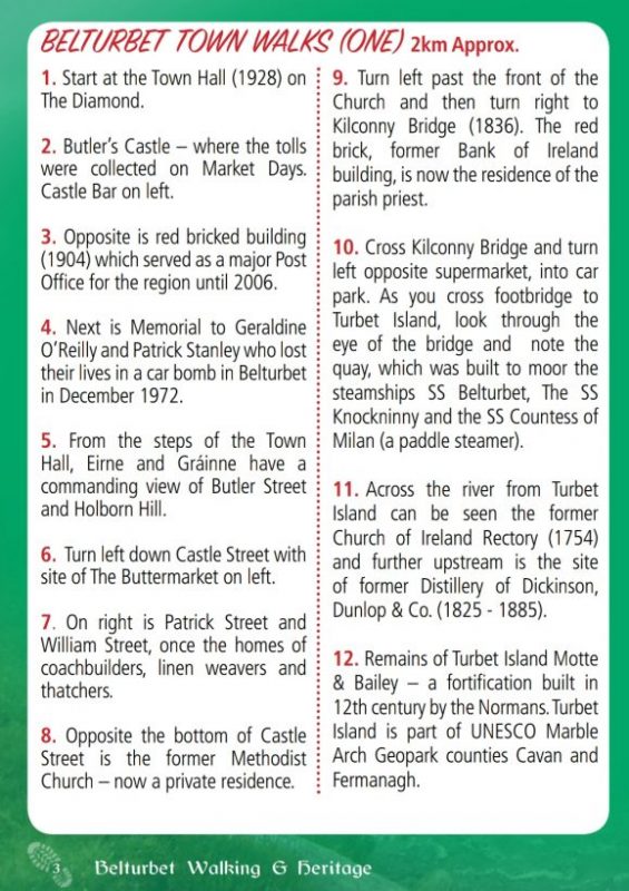
BELTURBET TOWN WALKS (ONE) 2km Approx.
1. Start at the Town Hall (1928) on The Diamond.
2. Butler’s Castle – where the tolls were collected on Market Days. Castle Bar on left.
3. Opposite is red bricked building (1904) which served as a major Post Office for the region until 2006.
4. Next is Memorial to Geraldine O’Reilly and Patrick Stanley who lost their lives in a car bomb in Belturbet in December 1972.
5. From the steps of the Town Hall, Eirne and Gráinne have a commanding view of Butler Street and Holborn Hill.
6. Turn left down Castle Street with site of The Buttermarket on left.
7. On right is Patrick Street and William Street, once the homes of coachbuilders, linen weavers and thatchers.
8. Opposite the bottom of Castle Street is the former Methodist Church – now a private residence.
9. Turn left past the front of the Church and then turn right to Kilconny Bridge (1836). The red brick, former Bank of Ireland building, is now the residence of the parish priest.
10. Cross Kilconny Bridge and turn left opposite supermarket, into car park. As you cross footbridge to Turbet Island, look through the eye of the bridge and note the quay, which was built to moor the steamships SS Belturbet, The SS Knockninny and the SS Countess of Milan (a paddle steamer).
11. Across the river from Turbet Island can be seen the former Church of Ireland Rectory (1754) and further upstream is the site of former Distillery of Dickinson, Dunlop & Co. (1825 – 1885).
12. Remains of Turbet Island Motte & Bailey – a fortification built in 12th century by the Normans. Turbet Island is part of UNESCO Marble Arch Geopark counties Cavan and Fermanagh.
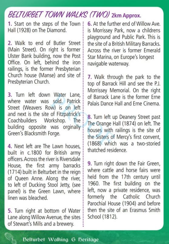
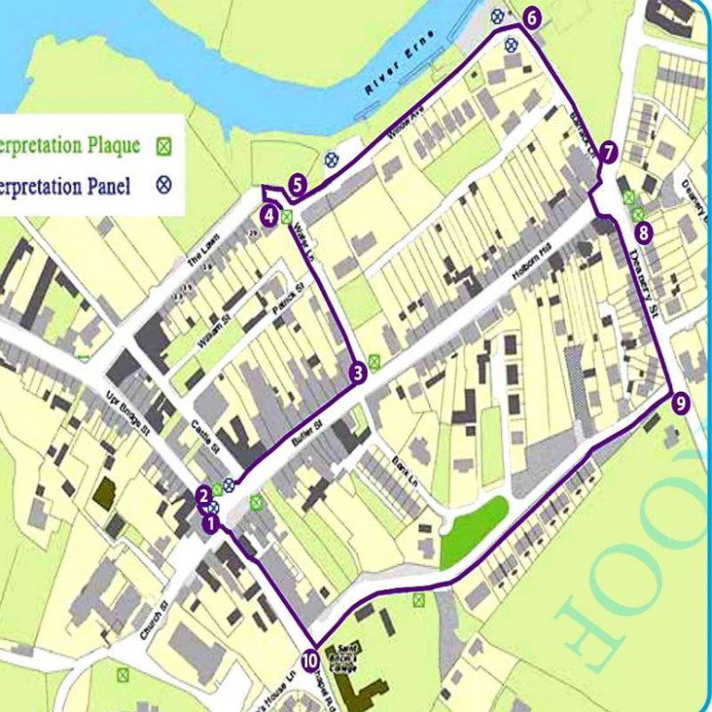
BELTURBET TOWN WALKS (TWO) 2km Approx.
1. Start on the steps of the Town Hall (1928) on The Diamond.
2. Walk to end of Butler Street (Main Street). On right is former Ulster Bank building, now the Post Office. On left, behind the iron railings, is the former Presbyterian Church house (Manse) and site of Presbyterian Church.
3. Turn left down Water Lane, where water was sold. Patrick Street (Weavers Row) is on left and next is the site of Fitzpatrick’s Coachbuilders Workshop. The building opposite was orginally Green’s Blacksmith Forge.
4. Next left are The Lawn houses, built in c.1800 for British army officers. Across the river is Riversdale House, the first army barracks (1714) built in Belturbet in the reign of Queen Anne. Along the river,
to left of Ducking Stool Jetty, (see panel) is the Green Lawn, where linen was bleached.
5. Turn right at bottom of Water Lane along Willow Avenue, the sites of Stewart’s Mills and a brewery.
6. At the further end of Willow Ave. is Morrissey Park, now a childrens playground and Public Park. This is the site of a British Military Barracks. Across the river is former Emerald Star Marina, on Europe’s longest
navigable waterway.
7. Walk through the park to the top of Barrack Hill and see the P.J. Morrissey Memorial. On the right of Barrack Lane is the former Erne Palais Dance Hall and Erne Cinema.
8. Turn left up Deanery Street past The Orange Hall (1874) on left. The houses with railings is the site of
the Sisters of Mercy’s first convent, (1868) which was a two-storied thatched residence.
9. Turn right down the Fair Green, where cattle and horse fairs were held from the 17th century until 1960. The first building on the left, now a private residence, was formerly the Catholic Church Parochial House (1904) and before then the site of an Erasmus Smith School (1812). Further down on the right is a cattle loading ramp and to the left is St. Bricin’s College (1937). This is the area originally known as ‘The Pleasure Gardens’ where the marquees for the carnival dances and circuses were erected.
10. Turn right to return to The Diamond.
BELTURBET TOWN WALKS (THREE) 2km Approx.
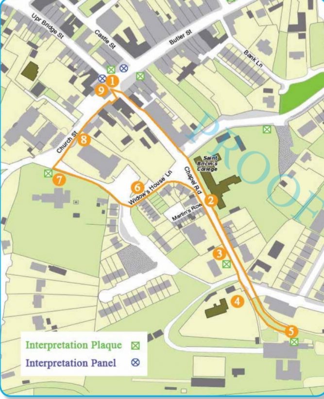
1. Start at The Diamond and turn right down Chapel Road.
2. Opposite St. Bricin’s College is Martin’s Row, houses built by a wealthy local business family for
their employees. Next is the Church of Ireland National School (1932).
3. The bungalow next is on the site of the old Catholic Church (1836- 1956). The surrounding wall contains some of the Church’s original stone. These stones were from the bridge demolished before Kilconny Bridge was built (1836) and were carried on the backs of local people, up Bridge Street (Strahaglan Street) to this site to build the church.
4. The St. Mary’s Boys National School (1956) next on the right. Opposite this is the building that was the Boys Old National School. (1853).
5. Ahead is The Great Northern Railway Station (1885-1959) and the Cavan and Leitrim Narrow Gauge Railway (1887-1959). The restored railway buildings are now owned by Belturbet Community Development Association and are
run as a Heritage Tourism Centre on a voluntary basis. Guided tours are available.
6. Retrace our steps up Railway Road. On right hand side are a number of Artisan cottages c.1800. Turn left up
Church Lane; Widow’s Row, single storied old houses on left, were built for Church of Ireland war widows
with a legacy from Mary Maunsell (1723). The two-storied house on the left was the Church of Ireland sextons residence. Here was born James Somers, the first Cavan man to be awarded the Victoria Cross in World War I.
7. The Church of Ireland (1828) is on the left. The remains of a Star Fort, an earthen fortification, is at
the rear of the graveyard.
8. The Catholic Church (1956) is on the right. Next is the Masonic Hall (1901). Opposite is Oriel Lodge, which replaced the convent of the Sisters of Mercy (1898-2001).
9. The Town Hall (1928) on The Diamond, with statues of Eirne and Gráinne, two ancient Irish Mythical Queens, has been refurbished (2014). Butler’s Castle (1720) was on the left where The Castle public house is situated.